Showing posts with label SUGAR CREEK. Show all posts

Saturday, September 3, 2016

RETURN TO TURKEY RUN STATE PARK

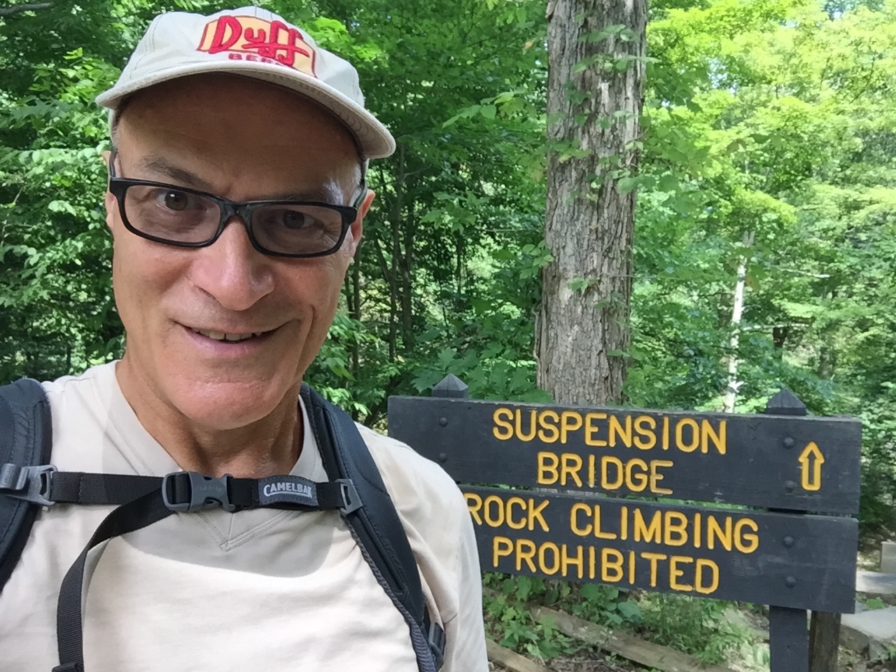
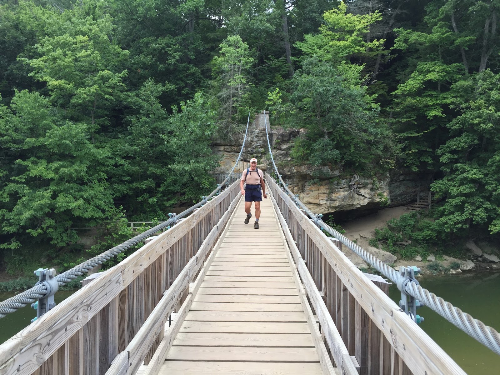
Early last month I discovered Turkey Run State Park. It is a beautiful Indiana State Park. The trails are spectacular as they are challenging but not overwhelming. Navigating the trails is not an endurance contest, but it does take a certain amount of concentration as one walks on wet rocks, narrow cliffs, over boulders and up and down steep staircases and ladders.  Yesterday was the day that I returned with my family. We had great fun. When I visited the park alone last month, I 'raced' through various trails and hardly took anytime to enjoy what I was seeing. The visit yesterday was not about trying to hike on every trail, but to enjoy the trails that we did hike. Still, when the visit to the park was over, we managed to hike 10 miles.

Park Entrance

'The Punch Bowl'

One of the three ladders that we had to navigate


You cannot imagine how difficult it was to climb up this steep, slippery rock. 

My daughter decided to experience Sugar Creek up close.

Daddy/Daughter selfie


.

Your Food Diary For:

BREAKFAST Calories
kcal
Carbs
g
Fat
g
Protein
g
Sodium
mg
Sugar
g
Mccain - Steel Cut Irish Oatmeal 300 54 5 8 0 2
Read - Three Bean Salad 300 65 0 5 1,500 55
Cliff Builders - Protein Bar - Chocolate 280 29 10 20 270 21

880 148 15 33 1,770 78
L U N C H
Subway - Footlong Turkey Breast on Wheat 560 92 17 36 1,890 11

560 92 17 36 1,890 11
D I N N E R
Denny's - Avocado Chicken Caesar Salad 500 11 37 35 1,249 2

500 11 37 35 1,249 2
S N A C K S
Sun Chips - Harvest Cheddar 210 27 9 4 320 3
Jack Link's - Matador Teriyaki Jerky 240 21 5 30 1,590 18
Fiber One - 90 Calorie Chewy Bars 450 85 10 5 400 25

900 133 24 39 2,310 46
Totals 2,840 384 93 143 7,219 137
Your Daily Goal 3,423 428 114 172 2,300 128
Remaining 583 44 21 29 -4,919 -9
Calories
kcal
Carbs
g
Fat
g
Protein
g
Sodium
mg
Sugar
g
*You've earned 1,493 extra calories from exercise today

If every day were like today...   You'd weigh 194.4 lbs in 5 weeks     
.

       Your Exercise Diary for:

Cardiovascular Minutes Calories Burned
319 1,773

   
Daily Total / Goal 319 / 30 1,773 / 590  
Weekly Total / Goal 915 / 210 10,409 / 4,130
.

SATURDAY IS WEIGHDAY
.
This week I checked in at 212.9 lbs. 
This is 2.7 pounds up from last week.
It always disappoints me when the scale points to the wrong number.
Here is my explanation.
I find it hard to believe that I really gained three pounds this week.
More likely, last week when I weighed myself, I might have been slightly dehydrated.
Perhaps this morning, I am more properly hydrated.
Anyway... What am I going to do?
I can answer that.
I am going to remember that on December 24, 2014, I weighed 309 lbs.
This means that I am 96.1 lbs less than I was on that day.
I think I will jump up and down a few times to celebrate that achievement.
And after that, I might take a hike.


.
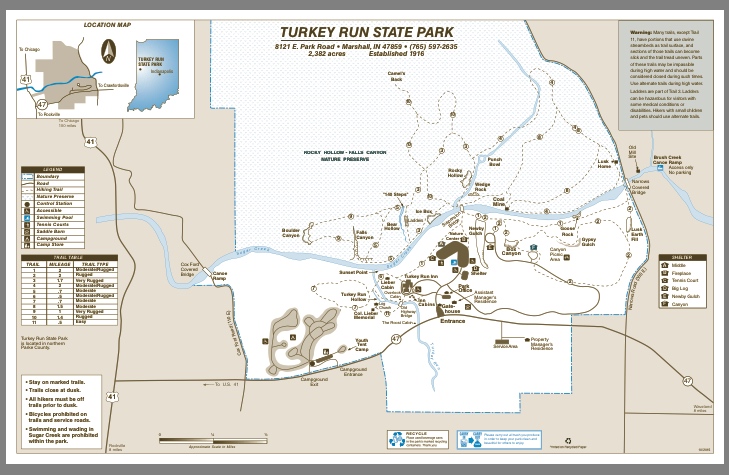
This section on the geology of the park was lifted from turkeyrunstatepark.com

GEOLOGY

In terms of history, the geology of Turkey Run State Park offers a unique view into the past. A walk into one of the ravines takes the visitor on a trip through time when the sandstone gorges represent 600 to 300 million years of nature's handiwork.
The exposed bedrock is Mansfield sandstone, after Mansfield, Indiana. This deposit was formed during the Carboniferous Period when the buildup of sand at the mouth of the ancient Michigan River was slowly compacted and cemented into solid rock. The swampy environment of this period gave birth to vast coal deposits. Coal was mined here in the late 1800's and early 1900's. Seams of coal are still visible along many of the trails.
More recently, during the Pleistocene Epoch, the sandstone bedrock was carved into today's familiar canyons and formations by the eroding action of glacial meltwaters. The Punchbowl on Trail 3 is an example of a pothole that was scoured out by glacial erratics caught in swirling backwash. Erratics are pieces of bedrock from Canada that were carried here by the glaciers. Some of the larger erratics, or boulders, can still be seen in Boulder Canyon on Trail 9, and smaller ones, pebbles, in Sugar Creek.
In the last few hundred years, the wind and water erosion of the sandstone has continued at a slower pace. The gorges are very similar to what was seen by Native Americans and pioneers.

Saturday, August 6, 2016

TURKEY RUN STATE PARK

Yesterday I found the best closest state park to my home city of Chicago - Turkey Run State Park.  Who knew that Indiana which is basically as flat as Illinois over much of the state was hiding this treasure. Until I 'discovered' this park on the internet on Thursday evening - I certainly did not know about it.
Turkey Run State Park is an Indiana state park located in Parke County, Indiana, in the west-central part of the state on State Road 47 2 miles (3.2 km) east of U.S. 41. It was Indiana's second state park, with the first parcel of land being purchased in 1916 at the cost of $40,200 when the State Park system was first established during the Indiana state centennial. It hosts the Turkey Run Inn, built in 1919. The origin of the name "Turkey Run" is unknown but the most accepted theory is that wild turkeys would congregate in the gorges (or "runs") for warmth where early settlers in the area would trap them in dead-end gorges and hunt them with ease.
A system of trails offers hikers plenty of outing opportunities during the summer months when the drainage is relatively free of water, and the suspension footbridge across Sugar Creek, the main drainage provides access to trails on the far side. Trail 3 is particularly noted for its ruggedness, including ladders and narrow but deep gorges. Floating down Sugar Creek through the park in either inner tubes, canoes, or kayaks is very popular in the summer months. There are 3-mile (4.8 km), 8-mile (13 km), or even 11-to-15-mile (18 to 24 km) trips down Sugar Creek. Also, in the spring when heavy rains and snow melt flood the narrow gorges, many more adventurous hikers will go "creek stomping" through the narrow gorges. However, the fast moving current, steep gorge walls, and unpredictable contours of the creek beds make this activity dangerous if the water level is high.
The hikes start by crossing a very beautiful suspension bridge.
The suspension bridge from Sugar Creek
This is me in the far distance on the suspension bridge that leads to the best trails
suspension bridge photo taken by a fellow hiker at the end of the day.
This was a 'selfie' taken when no one else was around to snap a photo for me at the start of the hike.


I had no major troubles traversing the water-starved creeks and wet rocks as my visit yesterday was  in late summer. Let me amend that. Twice I took a step and my left foot was completely engulfed in water. This is particularly funny to me. Last year when I purchased these hiking shoes for my hike up and down Half Dome in Yosemite - I purposefully did NOT buy shoes with water resistance.  I figured California was in drought and water resistance would have just added an unnecessary expense to the shoes. Two Things. First, although California was in a drought, we did managed to catch rain on our way down the mountain on that October day last year. Second, I apparently was unaware that hiking was about to become my favorite pastime. I believe my next pair of hiking shoes will be water resistant!
.
TURKEY RUN STATE PARK TRAIL MAP


.

This rock formation is called 'THE PUNCH BOWL'
During my twelve mile hike at Turkey Run, I climbed up and down a lot of wooden and stone stairs. In this photo I am standing in front of one of four LADDERS that needed to be climbed. They were much easier to climb up than to climb down.
This photo does not quite capture how narrow this passage nor how steep the steps were. You will just have to take my word for it.
Covered Bridge that dates back to 1882.
SUGAR CREEK
My twelve mile hike included walking on Trail 3 & 9 which are listed as 'VERY RUGGED' (No argument from me - These trails were not your basic 'Sunday walk in the park.'  I spent nearly five hours at the park and I did not see everything. I will definitely return to this park in the future. There is another park nearby which is said to be just as nice - SHADES STATE PARK.  Surely I will need to check out that park as well..


* * * * * * * * * *
SATURDAY IS WEIGH DAY.
223.3 lbs
I lost another 1.1 lbs this week.
That was 'easy.'
All I had to do was walk/hike 100 miles!
(Perhaps if I ate a bit less, my success would be more rapid.)  What's the hurry? This is a never-ending marathon. 

For the past three months, at the high-water mark of 241.9 lbs right in the middle of my recovery from a hernia, I have consistently been losing weight, virtually every week. 


* * * * * * * * * *

Your Food Diary For:

BREAKFAST Calories
kcal
Carbs
g
Fat
g
Protein
g
Sodium
mg
Sugar
g
Essential Everyday - Butter Flavored Grits 700 147 7 14 2,380 7

700 147 7 14 2,380 7
L U N C H
Subway - Footlong Turkey Breast on Wheat 560 92 17 36 1,890 11
Cashews - Dry Roasted & Unsalted 400 23 33 10 0 3

960 115 50 46 1,890 14
D I N N E R
Landshire Sandwiches - Ham & Cheese 520 64 16 36 2,480 14
Soft-baked Oatmeal Bar - Cinnamon 230 35 8 4 190 13

750 99 24 40 2,670 27
S N A C K S
Homemade - White Chocolate Chip Cookie 400 52 21 0 276 0
Nature Valley - Crunchy Oats & Honey 190 29 6 4 160 12

590 81 27 4 436 12
Totals 3,000 442 108 104 7,376 60
Your Daily Goal 3,881 485 129 195 2,300 145
Remaining 881 43 21 91 -5,076 85
Calories
kcal
Carbs
g
Fat
g
Protein
g
Sodium
mg
Sugar
g
*You've earned 1,951 extra calories from exercise today
If every day were like today...   You'd weigh 205 lbs in 5 weeks.

.


.

       Your Exercise Diary for:

Cardiovascular Minutes Calories Burned
HIKING 12 miles
283 1,951

   
Daily Total / Goal 283 / 30 1,951 / 590  
Weekly Total / Goal 1059 / 210 13,105 / 4,130             


Turkey Run State park
LocationParke CountyIndianaUSA
Nearest cityMarshall, Indiana
Coordinates39°53.1′N 87°12.2′W
Area2,382 acres (964 ha)
Created1916
Operated byIndiana Department of Natural Resources


I have always thought that a 'creek' by definition is a minor tiny place where water flows perhaps just a few miles long. My idea of what qualifies as a 'creek' apparently needs to be reassessed.

Sugar Creek is an 82.4-mile-long (132.6 km) tributary of the Driftwood River in east-central Indiana in the United States. Via the Driftwood, WhiteWabash and Ohio rivers, it is part of the watershed of the Mississippi River. Sugar Creek was likely so named from the sugar trees growing along its banks
.
Map from Chicago, IL to Turkey Run State Park, 8121 Park Road, Marshall, IN 47859
2 h 41 min (155.0 mivia US-41 S


* * * * * * * * * *

Sugar Creek is apparently a very popular name. I have hiked near a Sugar Creek in Ohio, Illinois and Indiana. They have nothing in common other than their name.

SUGAR CREEK WATERWAYS LIST FROM wikipedia.com


Tuesday, August 2, 2016

LOST BRIDGE TRAIL

Once I 'discovered' this trail searching for nearby trails along my route from Chicago to Staunton, it was imperative that I check it out. The name 'Lost Bridge Trail' was too interesting. The trail was a straight run from Springfield to Rochester, Illinois. In fact, the trail included two bridges, and neither seemed lost. So I needed to check with wikipedia.
The Lost Bridge Trail is a 5.0-mile (8.0 km) rail trail in Sangamon County, Illinois. It was built by the Illinois Department of Transportation (IDOT) along an abandoned Baltimore and Ohio Railroad corridor between the east side of Springfield, Illinois to the center of Rochester, Illinois.
The trail crosses the South Fork of the Sangamon River near Rochester, and crosses Sugar Creek near Springfield. Sugar Creek carries the outflow from Lake Springfield, a sizable nearby reservoir. The Lost Bridge trail name recalls IDOT's failure to prevent salvagers affiliated with the B&O from dismantling the Sugar Creek bridge for scrap.

After completing the 5 mile Lost Bridge Trail, I figured out another way to return to the trailhead where my car was parked. I often try to avoid a complete out and back route where I would simply retrace my steps. It is not always possible. My return trip was 6 miles.


.
I was tempted to walk into these cornfields and perhaps find out what happened to Terence Mann (James Earl Jones, Field of Dreams) but I didn't have my baseball glove with me and I wasn't in Iowa. There was no way of knowing where these Illinois cornfields might lead...

Film Field of Dreams  
Author Phil Alden Robinson  
Role Terence Mann  
Actor James Earl Jones 
Ray. People will come, Ray. They’ll come to Iowa for reasons they can’t even fathom. They’ll turn into your driveway, not knowing for sure why they’re doing it. They’ll arrive at your door, as innocent as children, longing for the past. “Of course, we won’t mind if you look around,” you’ll say, “It’s only twenty dollars per person.” And they’ll pass over the money without even thinking about it, for it is money they have and peace they lack. And they’ll walk off to the bleachers and sit in their short sleeves on a perfect afternoon. And find they have reserved seats somewhere along the baselines where they sat when they were children. And cheer their heroes. And they’ll watch the game, and it’ll be as they’d dipped themselves in magic waters. The memories will be so thick, they’ll have to brush them away from their faces. People will come, Ray. The one constant through all the years Ray, has been baseball. America has rolled by like an army of steamrollers. It’s been erased like a blackboard, rebuilt and erased again. But baseball has marked the time. This field, this game, is a part of our past, Ray. It reminds us of all that once was good, and that could be again. Oh people will come, Ray. People will most definitely come.


* * * * * * * *  
As I was finishing my hike I traversed this dam which appeared to be art deco in design. When I saw this sign, I realized that I had just about perfectly pegged the date of its construction. Once again, I consulted wikipedia to learn more about this dam.

Lake Springfield is a 4,260 acre (17.2 km²) reservoir located in the city of Springfield, Illinois, southeast of downtown. It is 560 feet (171 m) above sea level. It was formed in 1931-1935 by building Spaulding Dam across Sugar Creek, a tributary of the Sangamon River.
The lake was created, at a cost of $2.5 million in 1930s $USD, as a source of water for Springfield and to provide coolant for the City Water, Light & Power coal-fired electrical generating plant. It has also served as a focus of local recreation. Owners of high-powered motor boats enjoy the lack of a power limit on much of the lake, and the lake is known for warm-water fish such as largemouth bassbluegillblue catfishflathead catfish, and crappie.

.
Spalding Dam is on the northernmost part of Lake Springfield

* * * * * * * * * *
.
BREAKFAST Calories
kcal
Carbs
g
Fat
g
Protein
g
Sodium
mg
Sugar
g
Kroger - Grits, 2 cup 200 42 2 4 680 2
Trader Joes - Strawberry Cereal Bar, 1 bar 140 28 3 2 90 17

340 70 5 6 770 19
L U N C H
HYVEE - HUGE SPINACH SALAD 1,000 0 0 0 0 0

1,000 0 0 0 0 0
D I N N E R
Quaker - Rice Cakes 490 98 0 14 210 0
Campbell's - Chunky Soup - Hearty Beef Barley, 2 cup 280 48 3 16 1,580 12

770 146 3 30 1,790 12
S N A C K S
Natural Dark Chocolate 500 44 32 6 0 22

500 44 32 6 0 22
Totals 2,610 260 40 42 2,560 53
Your Daily Goal 4,943 618 164 248 2,300 185
Remaining 2,333 358 124 206 -260 132
Calories
kcal
Carbs
g
Fat
g
Protein
g
Sodium
mg
Sugar
g
*You've earned 3,013 extra calories from exercise today

If every day were like today...   You'd weigh 190.5 lbs in 5 weeks 
.

       Your Exercise Diary for:

Cardiovascular Minutes Calories Burned
165 1,888
Ic_i N/A 1,125

   
Daily Total / Goal 166 / 30 3,013 / 590  
Weekly Total / Goal 166 / 210 3,013 / 4,130             
.


* * * * * * * * *

.