Showing posts with label gorge. Show all posts

Wednesday, December 21, 2016

INDIAN CAVES

Natural Cave, maybe 20 feet deep into the rocks
Yesterday I had an appointment to sell fabric at a store in Bourbonnais, Illinois (approximately 50 miles from Chicago)  During my visit I let my customer know that I planned to take hike somewhere nearby before darkness set in)  My customer recommended that I visit the Indian Caves. I parked at Perry Farm Park and set out to see the caves.  I found only one small cave.  I believe that the other cave(s) were accessed by climbing down from the ravine that led to the creek. I did some exploring and after my feet broke through ice and got completely soaked, I lost some of my adventuresome spirit. I did see one cave that was visible from the trail and took a bunch of photos. The temperature seemed warm compared to my 3 mile hike on Sunday morning when it was -2F. Yesterday the temperature was a relative balmy 28°F.  It was plenty cold, and I was wearing 6 layers of clothing and brought better gloves with me. The hike was completed when I had travelled 6 miles.


Recommended parking is located at the Cavalier de LaSalle Park to the North, but is also available at the main parking area for the Perry Farm just off of Kennedy Dr. (Rt. 45) or at Lavesseur Park to the South. 


from geocaching.com


Before this area was settled by pioneers, Native Americans resided here for many centuries along the banks of what is now known as the Kankakee River. The Potawatomi Indians who called this place home actually called the River the "Theatiki", which only through a series of mispronunciations and misspellings became known by the settlers as the "Kankakee" River.

The Bourbonnais Geologic area, locally known as the Indian Caves, is located within the Perry Farm Park along the Kankakee River. The geological area includes the Bourbonnais Creek and ravine and covers approximately 30 acres of land. This area features a dolomite cliff and cave community, rare in the State of Illinois. On September 16, 1996, Governor Jim Edgar authorized the dedication of the Bourbonnais Geologic Area as an Illinois Nature Preserve in an attempt to protect it against vandalism and other destructive activities. It is open year round and its public use is limited to walking, exploring, and observing nature. Please remember to take care when exploring the cliff and creek areas and to take care of this rare natural resource.
The Indian Caves at this site are small, narrow caves that are readily accessible for exploration only to the most daring adventurers. The deepest of the caves is only about 20 feet deep, and requires entry through a very narrow crevice in the rock. Access to the caves can most easily be obtained by venturing back to the trail from the posted coordinates, walking North across the bridge spanning the creek, and following the dirt trail up and over the cliffs to the East. From there it will be evident how to get down into the ravine and ultimately to the caves. You can also follow the trail to the ENE of the posted coordinates, but the trail is not quite as defined and the climb may be a bit steeper..

.


This is from inside a small cave that was easy to find.


.

Your Food Diary For:

BREAKFAST Calories
kcal
Carbs
g
Fat
g
Protein
g
Sodium
mg
Sugar
g
Omelette - 3-egg Omelette With Cheese, 3 eggs 425 0 21 28 650 2
Essential Everyday - Butter Flavored Grits 500 105 5 10 1,700 5
Quest bar - cinnamon 170 23 7 20 200 1

1,095 128 33 58 2,550 8
L U N C H
Ham, Turkey, & Cheese on Honey Wheat Bread 620 68 22 44 2,900 16
Fit Crunch - Chocolate Chip Cookie Dough Bar                      380 27 16 30 320 6

1,000 95 38 74 3,220 22
D I N N E R
Taco Bell - Hard Shell Taco 850 60 50 40 1,550 5

850 60 50 40 1,550 5
S N A C K S
DARK COCOA MELTING WAFERS 660 72 39 9 135 63

660 72 39 9 135 63
Totals 3,605 355 160 181 7,455 98
Your Daily Goal 2,840 355 94 143 2,300 106
Remaining -765 0 -66 -38 -5,155 8
Calories
kcal
Carbs
g
Fat
g
Protein
g
Sodium
mg
Sugar
g
.

Your Exercise Diary for:

Cardiovascular Minutes Calories Burned
Bourbonnais Six Mile Hike
102 910
97 921


Daily Total / Goal 200 / 30 1,532 / 590  
Weekly Total / Goal 340 / 210 3,557 / 4,130             
.

.

.


I found this on wikipedia regarding the pronunciation of Bourbonnais.

Pronunciation

The original French pronunciation of Bourbonnais came to be Anglicized over time to /bɜːrˈbns/ bər-boh-nəs. In 1974 a state representative from Bourbonnais introduced a resolution "correcting" the pronunciation of the town's name to /bɜːrbəˈn/ burr-bə-nay, closer to the French.

.
Although it was cold hiking through the ice and snow on the trails, I kept warm as I was wearing six different layers of clothing.


Saturday, August 6, 2016

TURKEY RUN STATE PARK

Yesterday I found the best closest state park to my home city of Chicago - Turkey Run State Park.  Who knew that Indiana which is basically as flat as Illinois over much of the state was hiding this treasure. Until I 'discovered' this park on the internet on Thursday evening - I certainly did not know about it.
Turkey Run State Park is an Indiana state park located in Parke County, Indiana, in the west-central part of the state on State Road 47 2 miles (3.2 km) east of U.S. 41. It was Indiana's second state park, with the first parcel of land being purchased in 1916 at the cost of $40,200 when the State Park system was first established during the Indiana state centennial. It hosts the Turkey Run Inn, built in 1919. The origin of the name "Turkey Run" is unknown but the most accepted theory is that wild turkeys would congregate in the gorges (or "runs") for warmth where early settlers in the area would trap them in dead-end gorges and hunt them with ease.
A system of trails offers hikers plenty of outing opportunities during the summer months when the drainage is relatively free of water, and the suspension footbridge across Sugar Creek, the main drainage provides access to trails on the far side. Trail 3 is particularly noted for its ruggedness, including ladders and narrow but deep gorges. Floating down Sugar Creek through the park in either inner tubes, canoes, or kayaks is very popular in the summer months. There are 3-mile (4.8 km), 8-mile (13 km), or even 11-to-15-mile (18 to 24 km) trips down Sugar Creek. Also, in the spring when heavy rains and snow melt flood the narrow gorges, many more adventurous hikers will go "creek stomping" through the narrow gorges. However, the fast moving current, steep gorge walls, and unpredictable contours of the creek beds make this activity dangerous if the water level is high.
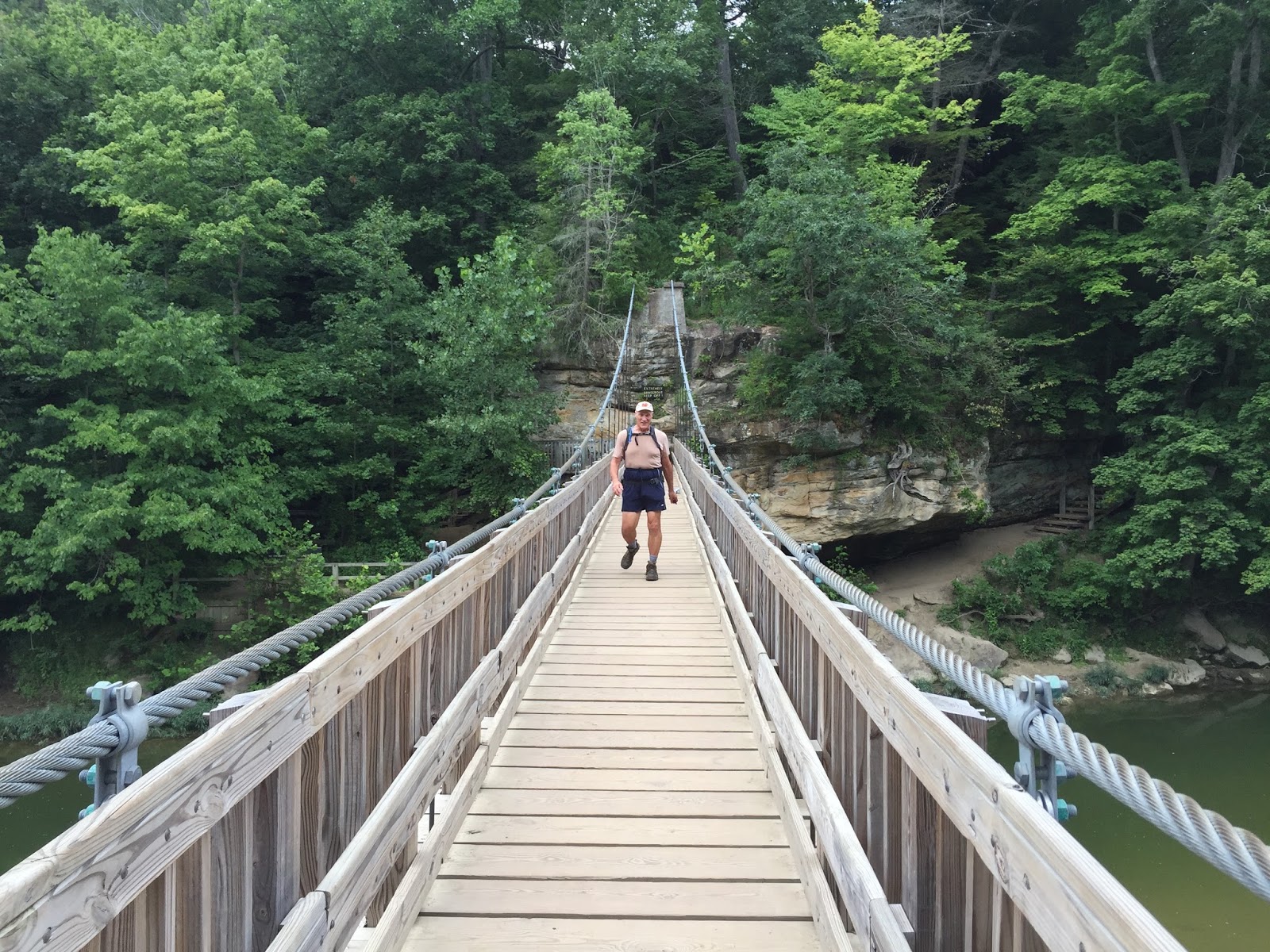
The hikes start by crossing a very beautiful suspension bridge.
The suspension bridge from Sugar Creek
This is me in the far distance on the suspension bridge that leads to the best trails
suspension bridge photo taken by a fellow hiker at the end of the day.
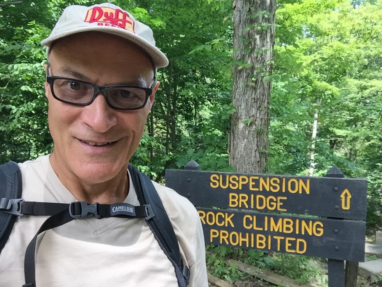
This was a 'selfie' taken when no one else was around to snap a photo for me at the start of the hike.


I had no major troubles traversing the water-starved creeks and wet rocks as my visit yesterday was  in late summer. Let me amend that. Twice I took a step and my left foot was completely engulfed in water. This is particularly funny to me. Last year when I purchased these hiking shoes for my hike up and down Half Dome in Yosemite - I purposefully did NOT buy shoes with water resistance.  I figured California was in drought and water resistance would have just added an unnecessary expense to the shoes. Two Things. First, although California was in a drought, we did managed to catch rain on our way down the mountain on that October day last year. Second, I apparently was unaware that hiking was about to become my favorite pastime. I believe my next pair of hiking shoes will be water resistant!
.
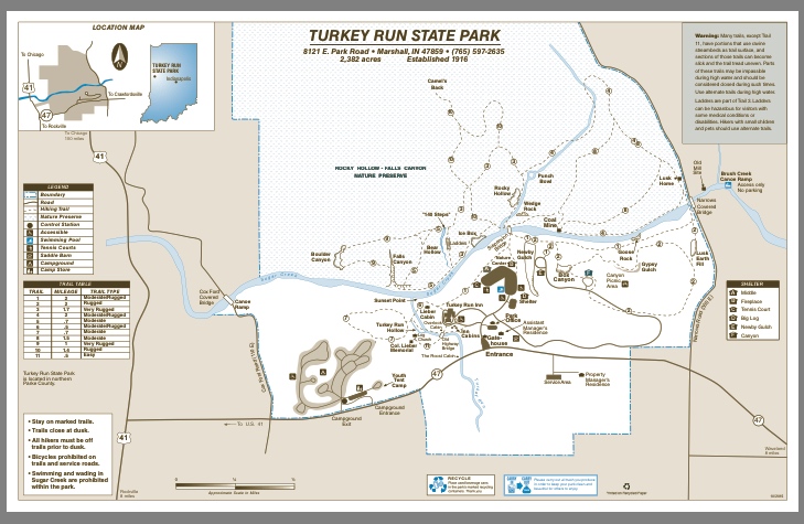
TURKEY RUN STATE PARK TRAIL MAP


.

This rock formation is called 'THE PUNCH BOWL'
During my twelve mile hike at Turkey Run, I climbed up and down a lot of wooden and stone stairs. In this photo I am standing in front of one of four LADDERS that needed to be climbed. They were much easier to climb up than to climb down.
This photo does not quite capture how narrow this passage nor how steep the steps were. You will just have to take my word for it.
Covered Bridge that dates back to 1882.
SUGAR CREEK
My twelve mile hike included walking on Trail 3 & 9 which are listed as 'VERY RUGGED' (No argument from me - These trails were not your basic 'Sunday walk in the park.'  I spent nearly five hours at the park and I did not see everything. I will definitely return to this park in the future. There is another park nearby which is said to be just as nice - SHADES STATE PARK.  Surely I will need to check out that park as well..


* * * * * * * * * *
SATURDAY IS WEIGH DAY.
223.3 lbs
I lost another 1.1 lbs this week.
That was 'easy.'
All I had to do was walk/hike 100 miles!
(Perhaps if I ate a bit less, my success would be more rapid.)  What's the hurry? This is a never-ending marathon. 

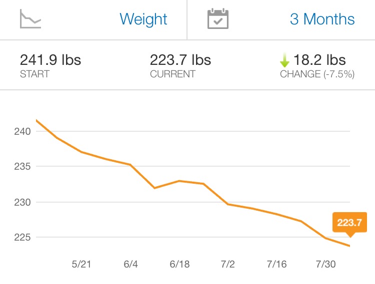
For the past three months, at the high-water mark of 241.9 lbs right in the middle of my recovery from a hernia, I have consistently been losing weight, virtually every week. 


* * * * * * * * * *

Your Food Diary For:

BREAKFAST Calories
kcal
Carbs
g
Fat
g
Protein
g
Sodium
mg
Sugar
g
Essential Everyday - Butter Flavored Grits 700 147 7 14 2,380 7

700 147 7 14 2,380 7
L U N C H
Subway - Footlong Turkey Breast on Wheat 560 92 17 36 1,890 11
Cashews - Dry Roasted & Unsalted 400 23 33 10 0 3

960 115 50 46 1,890 14
D I N N E R
Landshire Sandwiches - Ham & Cheese 520 64 16 36 2,480 14
Soft-baked Oatmeal Bar - Cinnamon 230 35 8 4 190 13

750 99 24 40 2,670 27
S N A C K S
Homemade - White Chocolate Chip Cookie 400 52 21 0 276 0
Nature Valley - Crunchy Oats & Honey 190 29 6 4 160 12

590 81 27 4 436 12
Totals 3,000 442 108 104 7,376 60
Your Daily Goal 3,881 485 129 195 2,300 145
Remaining 881 43 21 91 -5,076 85
Calories
kcal
Carbs
g
Fat
g
Protein
g
Sodium
mg
Sugar
g
*You've earned 1,951 extra calories from exercise today
If every day were like today...   You'd weigh 205 lbs in 5 weeks.

.


.

       Your Exercise Diary for:

Cardiovascular Minutes Calories Burned
HIKING 12 miles
283 1,951

   
Daily Total / Goal 283 / 30 1,951 / 590  
Weekly Total / Goal 1059 / 210 13,105 / 4,130             


Turkey Run State park
LocationParke CountyIndianaUSA
Nearest cityMarshall, Indiana
Coordinates39°53.1′N 87°12.2′W
Area2,382 acres (964 ha)
Created1916
Operated byIndiana Department of Natural Resources


I have always thought that a 'creek' by definition is a minor tiny place where water flows perhaps just a few miles long. My idea of what qualifies as a 'creek' apparently needs to be reassessed.

Sugar Creek is an 82.4-mile-long (132.6 km) tributary of the Driftwood River in east-central Indiana in the United States. Via the Driftwood, WhiteWabash and Ohio rivers, it is part of the watershed of the Mississippi River. Sugar Creek was likely so named from the sugar trees growing along its banks
.
Map from Chicago, IL to Turkey Run State Park, 8121 Park Road, Marshall, IN 47859
2 h 41 min (155.0 mivia US-41 S


* * * * * * * * * *

Sugar Creek is apparently a very popular name. I have hiked near a Sugar Creek in Ohio, Illinois and Indiana. They have nothing in common other than their name.

SUGAR CREEK WATERWAYS LIST FROM wikipedia.com